


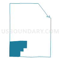
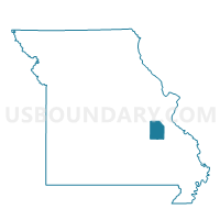
Pleasant Point Voting District, Washington County, Missouri
About
Outline

Summary
| Unique Area Identifier | 611550 |
| Name | Pleasant Point Voting District |
| County | Washington County |
| State | Missouri |
| Area (square miles) | 80.71 |
| Land Area (square miles) | 80.44 |
| Water Area (square miles) | 0.28 |
| % of Land Area | 99.66 |
| % of Water Area | 0.34 |
| Latitude of the Internal Point | 37.80899240 |
| Longtitude of the Internal Point | -91.01573480 |
Maps

Graphs
Select a template below for downloading or customizing gragh for Pleasant Point Voting District, Washington County, Missouri


Neighbors
Neighoring Voting District (by Name) Neighboring Voting District on the Map
- Belgrade Voting District, Washington County, MO
- Davisville Voting District, Crawford County, MO
- Huzzah Voting District, Crawford County, MO
- Shirley Voting District, Washington County, MO
- Viburnum Voting District, Iron County, MO
Top 10 Neighboring County Subdivision (by Population) Neighboring County Subdivision on the Map
- Courtois township, Crawford County, MO (1,300)
- Belgrade township, Washington County, MO (1,226)
- Dent township, Iron County, MO (1,194)
- Osage township, Crawford County, MO (1,171)
- Walton township, Washington County, MO (893)
- Harmony township, Washington County, MO (371)
Top 10 Neighboring Unified School District (by Population) Neighboring Unified School District on the Map
- Potosi R-III School District, MO (13,408)
- Steelville School District, MO (5,883)
- Valley R-VI School District, MO (2,931)
- Iron County C-4 School District, MO (2,879)
Top 10 Neighboring State Legislative District Lower Chamber (by Population) Neighboring State Legislative District Lower Chamber on the Map
Top 10 Neighboring State Legislative District Upper Chamber (by Population) Neighboring State Legislative District Upper Chamber on the Map
Top 10 Neighboring 111th Congressional District (by Population) Neighboring 111th Congressional District on the Map
Top 10 Neighboring Census Tract (by Population) Neighboring Census Tract on the Map
- Census Tract 4502, Crawford County, MO (4,215)
- Census Tract 4605, Washington County, MO (4,159)
- Census Tract 9501, Iron County, MO (2,841)